Life at Interfaces: Biocomplexity in Extreme Environments

hot spring banner
WELCOME to the NEW VERSION of the Idaho EPSCoR "Biocomplexity in Extreme Environments" webpage!

TERRESTRIAL LASER SCANNING:

Summary of results:

Principal Investigator: John Oldow (UI)

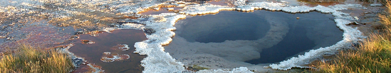
Active tectonic deformation (i.e., faulting) is one of the primary mechanisms giving rise to the existence of hot springs in the Alvord Basin. Active displacement along faults maintains conduits, or permeable flow pathways, that allow deep-circulating geothermal fluids to rise to the land surface. Microbial communities living in hot springs rely on the influx of heat and nutrients provided by the movement of groundwater in these active faults; therefore, the longevity of these communities is dependent on the temporal and spatial pattern of fault slip rates.

TLS in the field at Alvord 
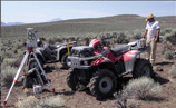
Terrestrial laser scanner used to acquire high-resolution digital elevation data.
-- photo by E. Singleton

High-resolution surface imaging with a terrestrial laser scanner (TLS; ground-based LIDAR) controlled by GPS positioning was applied on this project to constrain the spatial and temporal pattern of fault displacement by examining offsets in shorelines of ancient Lake Alvord. Because of the stability of wave-cut surfaces over distances of several kilometers, they provide an excellent vertical datum for measuring active fault displacement.

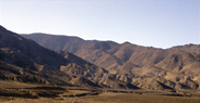
Shoreline terraces offset by recent normal faulting.
-- photo by E. Singleton
photo of shoreline terraces with fault offset, Alvord Point

Two sets of shoreline terraces were identified by this study: the lower (younger) set of shorelines have ages of about 12-17 ka, while the higher (older) set of shorelines have ages between 130-350 ka. Along an east-west transect across part of the basin fault system, we used TLS to determine vertical tectonic displacements of terraces across faults.
  • The highstand of the younger set of terraces is offset by 48.4 (+/- 0.5) meters.
  • The highstand of the older set of terraces is offset by 80.1 (+/- 0.6) meters.
  • Seventeen "displacement events" were identified.
  • Based on the magnitude of vertical displacement, each "event" probably reflects several earthquakes.
  • Displacement across the central Alvord Basin is concentrated primarily on one fault, yet a significant percentage (~35%) of the total offset is distributed among several other fault strands across the basin.
  • Horizontal displacement rates estimated from the younger terraces are up to 3.5 mm/yr (nearly twice the geodetic rate of 1.75 mm/yr).
  • Horizontal displacement rates estimated from the older terraces range from 0.13 to 0.36 mm/yr (nearly an order of magnitude lower than the geodetic rate).
Click on the images below to see digital ortho-photo quads (DOQs) and digital elevation maps (DEMs) of the Alvord Point study area. Fault locations are mapped in red; shoreline terraces are in yellow.
DOQ of central Alvord Basin
DOQ - central Alvord Basin
Close-up of Alvord Point.
DOQ - Alvord Point
3-D image of Alvord Point looking west.
DOQ - 3D view (west), Alvord Point
3-D elevation model (10-m DEM) of Alvord Point, looking west.
10-m DEM; 3D view, Alvord Point
Faults mapped in red; paleo-lake terraces in yellow.
DOQ with faults & terraces
Fault(red)/terrace(yellow) interaction at Alvord Point.
DOQ with faults & terraces, Alvord Point
3-D image looking west, with mapped faults (red) and terraces (yellow).
DOQ - 3D view (west), Alvord Point
3-D high-resolution elevation model derived from TLS.
TLS DEM; 3D view, Alvord Point

Implications for local and regional structure and tectonics:
  • Faults in and around the Alvord extensional basin have experienced an elevated period of displacement rate (earthquake cluster) in the latest Pleistocene to middle Holocene.
  • Average displacement rates since the latest Pleistocene are consistent with geodetic rates suggesting that far-field displacement and strain accumulation are constant for the fault system over the last 10,000 years.
  • Reduced rates for late Pleistocene shorelines suggest either a slower far-field displacement rate or that the locus of deformation moved within the basin and/or to locales outside of the basin fault system.
  • Concentration of earthquake surface ruptures on individual strands of the Alvord fault system together with the distributed nature of cumulative displacement across the basin suggests that strain release and recurrence interval for earthquakes vary spatially within the fault system.
last update: June 2006 | webmaster: jhinds@uidaho.edu