Introduction
TR-55 stands for Technical Report 55. This uninspired title refers to a stormwater runoff rate and volume calculation methodology developed by the US Government in 1986 and updated as a public software program called WinTR-55. It is a Windows based program. We will use it this semester to estimate pre- and post-development runoff situations. However, the software is also available in the UI College of Art and Architecture computer studio.
Resources and Perparation
Please visit the NCRS web page and download the program and all of the support and training material. If you have a Macintosh computer, you can use the program on computers in the A&A Cad Lab. Even if you use a Mac, you can download the support and training materials.
Before the next class meeting (Feb. 3) study the "WinTR-55 Tutorial" and the "WinTR-55 Presentation for Experienced Users". Both of these Powerpoint presentations are available on the NCRS page noted above.
After you have reviewed the Powerpoint presentations, open the WinTR-55 user manual (2009) and complete Example 1, Part A (it begins on page 58 of the pdf document). You are to complete this assignment using the WinTR-55 software before class. Name the file "your last name Ex1Apre". The goal of this assignment is to make you familiar with the softwater and to acheive the same result as the example.
Storm Overview
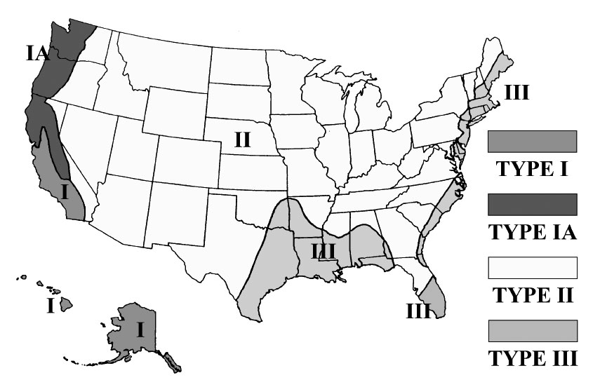
Storms have characteristic patterns that vary by region. Enlarge the map above to determine the storm type for your area. WinTR-55 requires this information.
Despite the general characteristics, the average rainfall amounts will differ for almost every city. Precipitation is measured in different ways, but for stormwater management rainfall averages are expressed as inches of rain over specific units of time. Data is available for six hour storm periods to identify intense storm events. Individual storms that cause property damage or loss of life are recorded and reported for every area of the nation. However, the most commonly used information in designs for stromwater management is rainfall depth over 24 hours. This data is divided into categories based on the likelyhood that storms of certain magnitude will occur. When we speak of a 100-year, 24-hour storm we really mean that a storm of a certain magnitude has a 1% chance of occuring during any year. Similarly, a 2-year, 24-year hour storm has a 50% chance (100/2) of occuring during any year. Agencies define the magnitude of storm that must be managed on the site. This is called the "design storm". For example, the design storm for water quality treatment might be the 2-year, 24-hour storm while the design storm for protection of off-site srtreams is the 25-year storm.
TR-55 will automatically determine the rainfall amounts for most locations when the county is identified on the entry screen dialog box, but for some areas this is not done automatically. If this is true for Whitman county, Washington you would need collect this information from NOAA and enter it into WinTR-55. For Colfax the data is:
| 24-Hour Storm | Rainfall - inches |
|---|---|
| 2 | 1.8 |
| 10 | 2.4 |
| 25 | 2.8 |
Runoff Overview
Some rainwater is retained on-site. The amount is related to the slope, soil type and surface material. Therefore, TR-55 will request all of this information from you for each drainage area in the project. If you keep this in mind as you prepare your site design, you can collect information (or at least draw polygons around each of the surface types) as you make design decisions. TR-55 automatically estimates the amount of water contained on the site before water begins to runoff. This is called the initial abstraction. TR-55 uses a runoff curve number to express the percentage of water that is expected to runoff given the soil texture and the cover type. For example, a silty loam soil with lawn in good condition has a runoff curve number (CN) of 74. This indicates the 74% of the storm water will runoff.
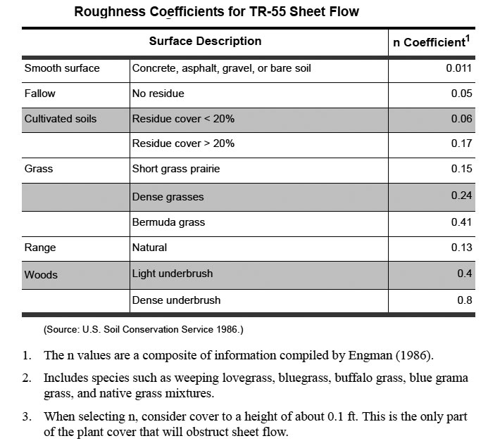
The rate of runoff is also a concern. To estimate this WinTR-55 needs information about slope, the roughness of the surface and the type of runoff. The slope is expressed as a decimal (0.02 = 2%). The roughness indicates how much resistance to flow there is. TR-55 uses the Manning equation to estimate this. The tables above list a number of Mannings's roughness corfficients. Notice that in the table on the left that land surfaces and sheet flow are listed. Sheet flow is runoff where water is very shallow and fully distributed across the slope. In TR-55 the maximum length for sheet flow is 100' after which it is defined as shallow concentrated flow. This means that the water still flows in a sheet but is deep enough that the surface influence is reduced. The second table above provides roughness coefficients for channel and pipe materials.
The three categories of runoff in TR-55 are sheet, shallow concentrated and channel. Channel runoff is when water in concentrated in a swale, gutter, ditch of pipe.
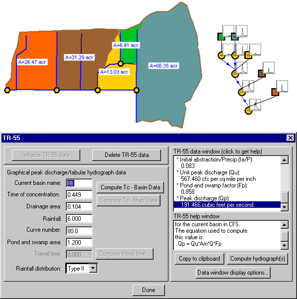
Drainage Areas Overview
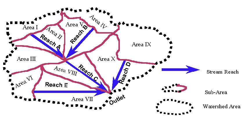
TR-55 anticipates a site drainage sequence. A site with a single drainage area (catchment) drains to an outlet. A more complex site will have several subdrainage areas (enlarge the image above). Runoff can sheet flow across a subdrainage area, but flows into a reach (swale, stream, ditch or pond). Reaches can drain into each other but eventually flow to the watershed outlet.
In-Class Activity and Required Data
In class you will take advantage of your experience with TR-55 to complete a pre-development runoff estimate for the site that we are using for the semester project this year.
To complete the in-class assignment you will need to bring the following data to class,
The area of the site in acres. The area of the wooded portion of the site (acres). The longest distance to the low point along Sweet Avenue.
The 2, 10, 25, 50 and 100-year 24-hour storm precipitation depth in inches. This information is available through the US National Oceanic and Atmospheric Administration at http://www.nws.noaa.gov/oh/hdsc/currentpf.htm#PF_documents_by_state.
Study Questions
What is the chance that a 5-year, 24-hour storm will occur duing any year?
What is a "design strom"?
Define initial abstraction.
Which two factors determine a runoff curve number (CN)?
What is the maximum length of sheet flow according to TR-55?
What is shallow concentrated flow?
Which drainage structures can be defined as a "reach"?
References
NCRS. 2009. Small Watershed Hydrology. .