| |
|
Main Menu |
|
|
|
Collaboration |
Your faculty value the opportunity to collaborate and believe this kind of interdisciplinary effort is necessary for the best community planning and design solutions. Therefore, they ask that you adopt the goal of forming effective interdisciplinary partnerships in this course and in your professional career.
Demonstrate Teamswork! |
|
|
|
Welcome |
Transit Oriented Design
Study Questions
- This page includes the following sections. Click on thumbnail images for an enlarged image in a new window.
Open space:
Green space
Public plaza
Recreational space
Access
Summary
|
Transit Oriented Design is an urban planning and design concept formulated and implemented by Peter Calthorpe and others although the concept has its historical roots in the English Garden City Movement and in the American suburban development proejects in the 1880's. This web page is an informational resource for urban planning and design in creating sustainable communities.
|
|
Suburbanization
|
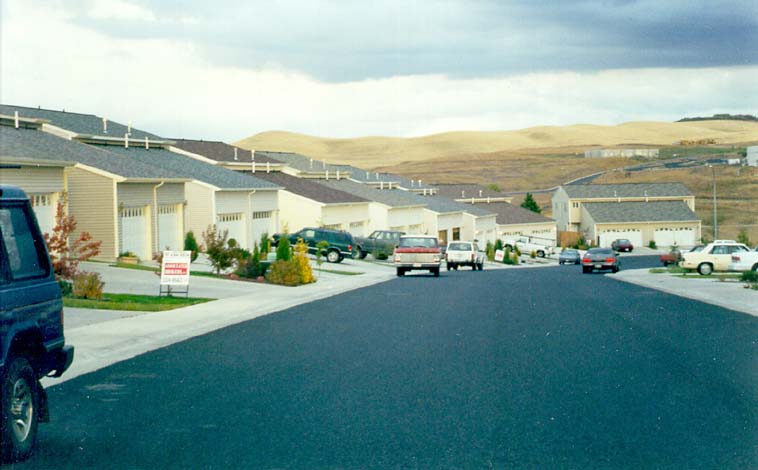
Cities have become metropolitan areas. They are regional cities that cover vast land areas and are home to most of the population of the United States. The expansion of suburbs around cities was largely the result of "white flight" to the suburbs in the 1960's and 70's. Wealthier Americans seeking to escape the congestion and crime of the city purchased single family homes isolated from the urban structure except for the freeways that took them to the city for work and cultural events.
The escape was short lived. Drugs, crime and an increasingly difficult commute were soon added to the isolation of suburban living. Transit Oriented Design is a response to the failures of suburban development. Those failures include the lost of agricultural land, natural habitat and the amenities of urban life.
 Isolation of auto oriented subdivisions Isolation of auto oriented subdivisions
|
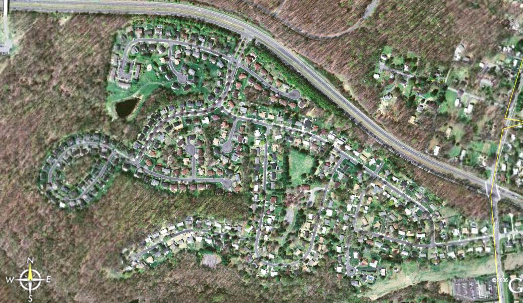
 Loss of Habitat and Agricultural Land (Google Earth, 2007) Loss of Habitat and Agricultural Land (Google Earth, 2007)
What caused the expansion of the suburbs in the 1960's and 70's? |
Principles
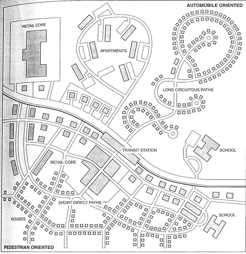
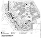
TOD and subdivisions compared (Hooper, 2007)
According to the course web site the regional city should be planned and developed to express which four characteristics?
|
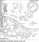
The auto oriented residentialsubdivision is contrasted with the transit oriented design in the image at left.
While the transit oriented community is usually on the outskirts of the regional city it does not deny the dominance of the regional city as the center of culture, employment, and financial institutions and rven shoppint.
The regional city should be planned and developed to include the following 4 characteristics 1) a limited number of parking spaces in the downtown 2) a maximum area defined by a growth limit line to preserve agriculture and natural systems 3) smaller cities and towns arrayed around the regional city should be planned according to location, density and their own growth limit boundaries 4) the satellite cities should be linked to the central city by public transportation.
|
 TOD and subdivisions compared (Hooper, 2007) TOD and subdivisions compared (Hooper, 2007)
About how far are Americans willing to walk to take public transportation?
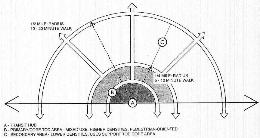
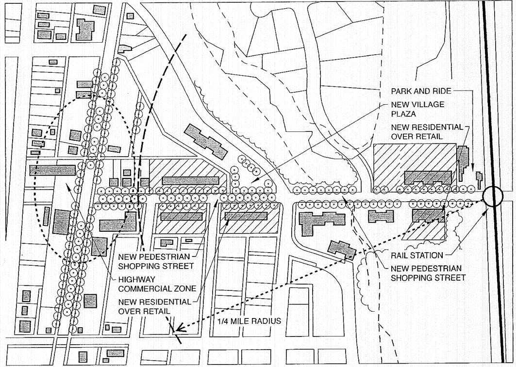
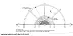
Diagram the conceptual layout of a transit oriented development. Note the distances of zone edges and the distance that the typical resident is willing to walk to the mass transit stop. |
Light rail transit stations outside of the regional city become the center of new neighborhoods in the satellite cities. In this diagram the typical planning pattern is presented. Enlarge the image and note the three zones. Residents are willing to walk about 10 minutes or 2000' to take public transit. Therefore, the arrangement of commercial and residential elements are clustered in compact high density buildings near the transit station.
The diagram below illustrates the ideal schematic of the transit village - a new town on a brown field or green field site. In fact, the establishment of the light rail station motivates development according to the land use and density established by the transportation or municipal agency.
 (Hooper, 2007) (Hooper, 2007)
|
Design
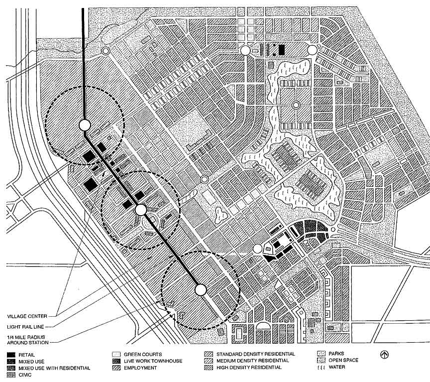
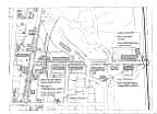
 Daybreak UT master plan (Hooper, 2007) Daybreak UT master plan (Hooper, 2007)
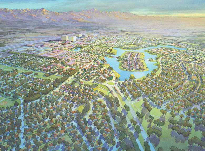
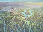 (Calthorpe, 2007) (Calthorpe, 2007)
|
There must be trade-offs for high density living. They are often related to access to urban amenities and economics. Proximity to neighborhood shops that provide all of the goods necessary in our daily lives, and proximity to high quality open space and efficient public transportation are some of these amenities.
Enlarge and study this design proposal for a large transit oriented community (Daybreak Utah)to identify the features of urban life in the satellite city. The dashed circles represent 1/4 mile radii identfying pedestrian oriented districts at transit station. The color perspective shows the character of the proposed development on a brown field site near Salt Lanke City.
A 1995 study compared 19 light rail lines and 261 stations and found that for every 10% increase in population density there was a 6% increase in boarding at light rail stations. Light rail lines that went through areas that had densities of 20 people per acre could expect daily boarding of 2000 people, and neighborhoods with densities averaging 5 people per acre only averaged 900 daily boarding.
|
|
Trends
|
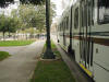
About 200 cities across America are implementing or planning light rail transit systems. Portland's experience is that fares cover the cost of construction in as little as 5 years. Fares also cover 65% of the cost of operation compared to highway systems where none of the cost of construction or operation is recovered from the users. Users are commuters, students, shoppers and tourists. Public transportation provides a way for people of all ages to get around. Often the poor, disabled, elderly and the young are stranded in the suburbs or city if they don't have a car.
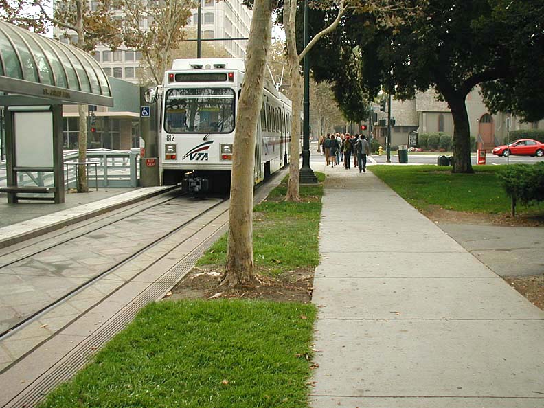
Note that in this image of a light rail train in San Jose, California the stop reaches office uses (left) a public park (right) and is accessible by the handicapped.
|
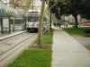
(Austin, 2007) Light Rail Train in San Jose, California
|
Physical Infrastructure
|
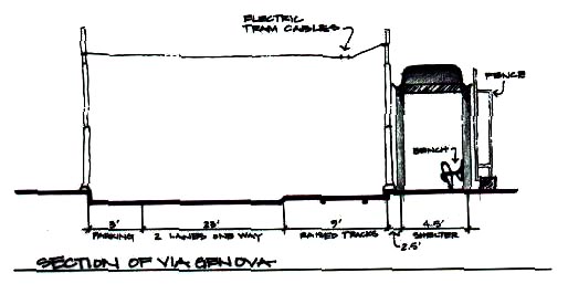
Light rail trains have a size and speed compatible with other vehicles. The first image illustrates the design of a one way street that is shared by light rail, buses and private automobiles. Enlarge and study the image. It includes two traffic lanes for autos and buses. A third raised lane is for public transportation vehicles, including electric light rail and buses. Parallel parking is provided on the side opposite the transit line. The width of the street is about 40 feet. The waiting area is covered to protect the transit user from sun and rain. The waiting booth is about 4 feet wide and held back form the curb 2 1/2'.
The second image shows two lanes for automobile traffic and a raised light rail transit area that is shared with the pedestrian complete with street furniture. This image is from San Jose, California.
|
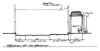
(Austin, 2005)
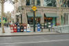
(Austin, 2005)
|
Convenience
|
The convenience of mass transit and the private automobile depends on with availability and reliability. To compete with the auto, public transportation must be located within 2000' of the users home, work and shopping destinations. Another aspect of convenience is timeliness. Trains should arrive at stops every 15 to 20 minutes. This means many trains per route or short routes. Typically as residential density decreases so does frequency of trains. One way to improve the time it takes for the train to travel the route is to provide a lane solely for a public transportation. In this case the train can travel more quickly through a city than congestion bound autos. Use of public transportation is encouraged when traffic laws favor public vehicles and when access to parking for private autos is rare or expensive.
An example of a traffic rule favoring public vehicles is a requirement that a bus or a light rail car, stopped at a traffic light, is permitted to move through the intersection before private automobiles move when the traffic light turns green. This causes public vehicles to move more quickly through congested areas than private autos. This increases the convenience and desirability of public transportation.
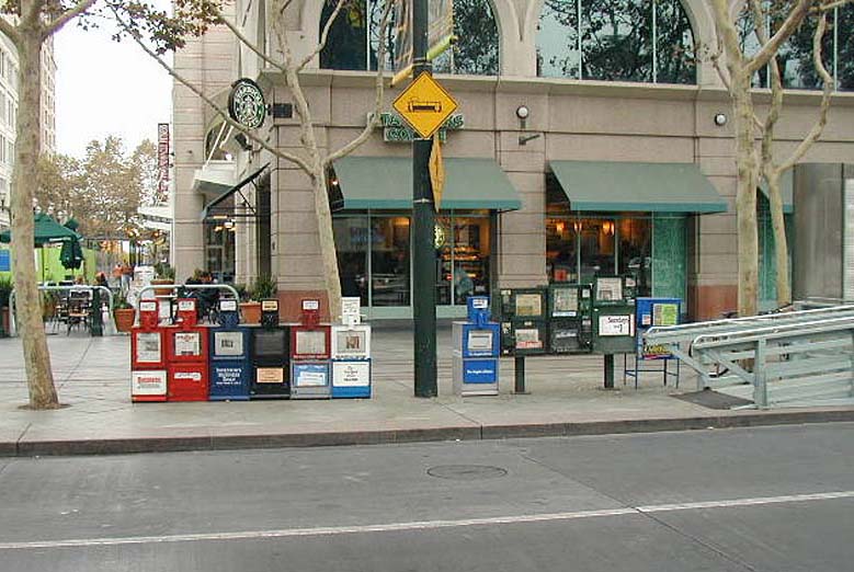
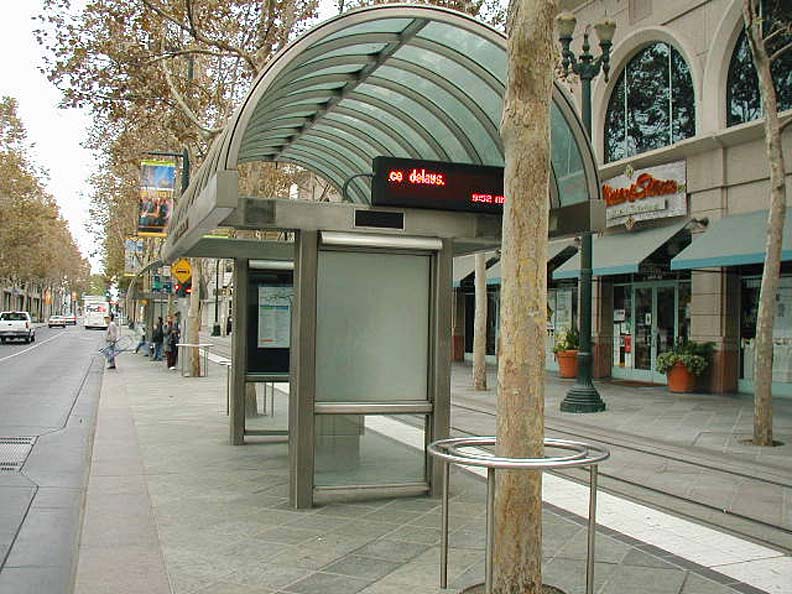
Protecting the waiting passenger at the light rail stop is another important consideration. Shade and cover from rain as well as convenient ticket purchase and comfortable street furniture help make the public transit commute pleasant. In the first image in this section, notice the following features: places to sit, stand, and lean; places to get out of the weather, view routes and schedules and buy tickets from vending machines. In the second image other amenities are shown including a public restroom (the small building beyond the mail box), trash receptacle and mail box.
Discuss two ways that public transportation speed can be improved through design or policy measures.
|

Transit shelter, San Jose, Calif. (Austin, 2005)

Street furniture (Austin, 2005)
|
Route Information and Safety
|
Of course, the public transportation system must be managed well. Cars must be clean, safe and reliably on time. In addition to safety users must be assured that they will not be harassed by other users. Fixed schedule transportation is where buses or street cars arrive at the same scheduled time at each stop each day. In an open schedule system, buses and trams circulate at specified intervals rather than set times.
|
 (Austin, 2005) (Austin, 2005)
|
Aesthetics
|
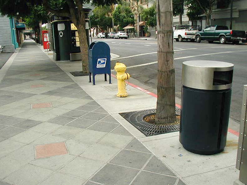
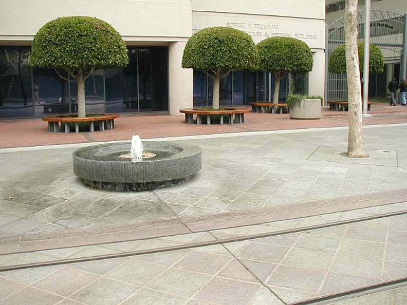
The public landscape should be beautiful. Fine, long lasting materials along with fountains and public art enrich the quality of life and encourage use of the public infrastructure.
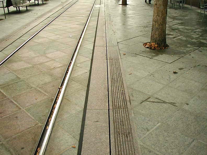
The first image here shows the flush paving and light rail tracks of the San Jose system. The corridor becomes a public plaza space shared by the light rail vehicles. It enhances pedestrian access.
|
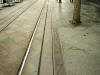
Paving (Austin, 2005)
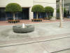
Fountain (Austin, 2005)
|
.
|
|
Past Projects of This Studio |
We have contributed to the positive planning and design efforts of many communities during the ten years that this combined studio has been doing outreach work. We have worked in these Idaho communities: Orofino, Riggins, Grangeville, Harrison, Hayden, Sandpoint, Lewiston, Star, Rupert, New Meadows, McCall; these Washington communities - Clarkston ; and these Montana communities - Seeley Lake.
|
|
|
|
|